Guest Blog | Cynthia McArthur: Galapagos

From Tourists to Family, Observations of Student Evolution in the Galapagos

cindy macarthur

Blog by Cynthia McArthur, PVS Volunteer, ‎National Partnership Coordinator at USDA Forest Service, and a chaperone with the Hawaiʻi student delegation in the Galapagos

Being able to explore the Galapagos Islands with the Hawaiian Student Delegation to support Hōkūleʻa and the Worldwide Voyage was a dream come true. Although I found the famous Darwin finches and giant tortoises fascinating, I was more intrigued by the changes I witnessed in the students. Through the photos and examples below, I will playfully demonstrate how key evolutionary concepts that typically take generations to manifest were witnessed in just a few days by our students living on a new and foreign island called Santa Cruz.

touristbus

The ABCs of evolution:

A. Adaptation: a trait that helps an organism survive in an environment.

B. Competition: when resources like food and water become limited, species must compete to survive. Competition is part of natural selection or survival of the fittest.

C. Galapawareness: a new term invented by the students to emphasize culturally sensitive conservation efforts. Galapawareness means learning to conserve natural resources and care for each other like a family.

Example #1 limited fresh water. We quickly learned that American style showers in the Galapagos were not sustainable. Regularly, the power would go out and the water pump would stop the flow of fresh water. During one occasion, we accidentally used all the water in the hostel’s storage tank and had to wait until morning for the water delivery truck. No showers, no flushing toilets. Naturally, under these unfamiliar circumstances, students with short hair were better adapted to survive. However, students defied Darwin’s theory of competition by sharing their own bottled drinking water to remove shampoo out each other’s eyes and hair.

Example #2 limited understanding of the local language. Students quickly adapted to the language barrier by learning, laughing and repeating important phrases. Fortunately, one member of our twenty-seven person team spoke fluent

Spanish so we didn’t get into too much trouble. The language barrier led to some pretty cool experiences when we realized the spirit or mana of traditional Hawaiian chants like Oli Mahalo needed no translation to be appreciated by local residents. We also discovered that songs by Justin Bieber and Vance Joy’s Riptide were part of a bizarre universal language that all the students from both countries understood perfectly.

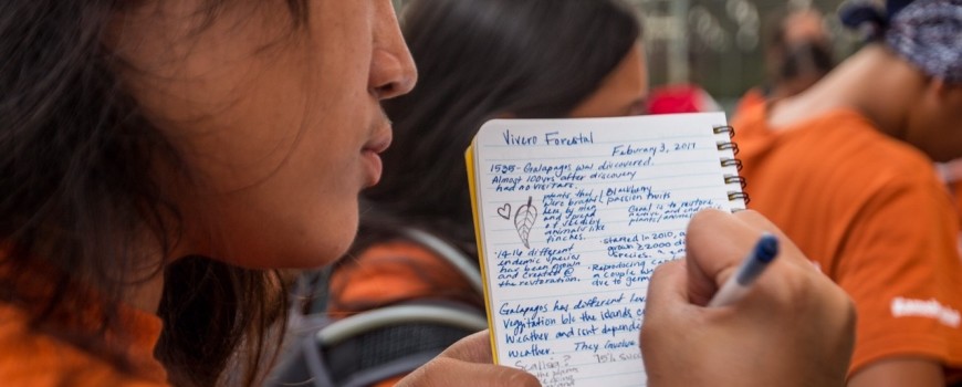
Example #3 limited access to Wi-Fi and mobile technology. Wi-Fi is an endangered species in the Galapagos. Students who were used to working almost exclusively on mobile devices at home evolved to recording their observations in weather resistant field notebooks by hand. Because the internet was challenging to access, students adapted their research techniques drawing from personal observations and face to face interviews with local experts and scientists. Besides, who needs Google when we had Dr. Sam ʻOhu Gon on our highlands expedition!

In conclusion, the most inspiring part of the evolutionary changes witnessed during our adventure in the Galapagos is that they will live on when the students return home. Watching these young people working together makes me believe that Hōkūle’a will be in good hands. I am confident these students will successfully adapt to the many new challenges and environments they will face in the future.

Hōkūleʻa Update | Navigation Basics – Part 2

Blog by Haunani Kāne Haunani_Kaneand Jason Patterson jason_Patterson

Aloha nui kākou,

Prior to leaving the Galapagos, our navigation team worked with Nainoa and our Captain Uncle Archie to develop a sail plan and a course line that we would reference to keep track of our direction and distance traveled as we sail to Rapa Nui. Our reference course started at Isla Espanola and takes us on the southwesterly course of Nalani Kona (213°, or 33.75° west of south), which leads to a point 90 miles east of Rapa Nui. Then, at Rapa Nuiʻs latitude (27° south), we will make a right turn and sail Komohana (west) towards the island. The primary job of the navigator is to keep a running tally of how many miles east or west the waʻa is of our reference course; this daily total is calculated based on what we have determined about speed, direction, winds, swells, etc. The winds slowly transition from light southerly or variable doldrum conditions near the Galapagos, to a more southeasterly or tradewind flow further south. Every day, we have been sending in our navigation update with this information, for those who are following our navigation route.

We are concerned that if we are not precise with our steering that we may fall west of our reference course, and miss our remote target. Because of this, we have spent the past four days sailing slightly east of our reference line to account for drift and current, and to give us an additional 150 mile buffer – buying us an extra day on our westerly, downhill run as we search for the island.

The way in which we account for how much east or west we have sailed over the course of a day in relation to our reference line is by using a deviation table. Nainoa constructed this deviation table to assist him during the 1980 sail, when he successfully navigated round trip from Hawaiʻi to Tahiti and back. The deviation table is derived off of the average sailing day, where the canoe travels 120 nautical miles in a day at 5 knots.

deviations

We memorize this table to know just how far east or west of our reference course we have traveled for every star compass house that we deviate from our reference course. For example, if our reference course is Nālani Kona but we actually travel Nā Leo Kona (one house east of Nālani), then over the course of one day we would be 24 miles east of our reference course. Expanding on this 5 knots table, we also calculated deviation tables for varying speeds to keep a more accurate account of our variance between 2 and 10 knots.

Over the last few days, we have broken up into two navigation teams and taken 24 hour shifts. Our job while on the watch is to trim the canoe’s sails and adjust weight so that we sail a straight course without the use of the hoe (steering paddle). We are using the sun, swell and wind in the daytime, and the stars at night when they are available. The large moon has been both a blessing and a challenge as it dims the light of faint stars.

This morning our navigation team determined that we are about 949 nautical miles south of our starting point and 303 east of the Nālani Kona reference line. Our estimated latitude is about 17 degrees south – in our next navigation basics blog, we will discuss how we can use stars to help determine our latitude.

Stay tuned, and don’t forget to check out hokulea.com for all the latest info on our voyage.

Aloha,
Haunani and Jason


Homecoming__-_Save_the_Date_-_Banner

Hōkūle‘a Homecoming – Save the Date

Sign up for updates and be the first to know as we continue to detail homecoming festivities during the week of Hōkūleʻa’s homecoming
on June 17, 2017!

Hōkūleʻa Update | February 19, 2017

Navigation Update
Voyage Day: 10

Sunset update by Noe and Lehua

Speed and location:
Canoe average speed: 6 kts
12 hour estimated total: 57nm South, -4 nm East
Leg estimated total: 1144 nm South, 299 nm east
Latitude: 20.34 South (est DR)

Heading
Nālani to Noio Kona

Wind:
AM: 10-12 kts; PM: 10-15 kts

Swell direction and height:
1. Noio Malanai
2. Hikina
3. South Hema, long period 6 ft

Cloud type and %cover: Mostly low level, 15%

Temp: 75 degrees

Rig: at sunset, 23 Genoa, 36 triangle main, 36 triangle mizzen

Wildlife: lots of malolo and three unidentified blue birds

———–

Repetition

When my brother and I were little, our father used to tell us that it wasn’t practice that makes perfect (as most people say); rather, good practice is what could make perfect. I have pondered on that little nugget of wisdom throughout my life, and while I’ll leave perfection to akua, I am a big believer in the “good practice” part of the statement.

Out here on the canoe, every experience is geared towards practice through repetition. The watches require us to practice all aspects of running the canoe, from things we have done hundreds or thousands of times like adjusting sails or checking lines, to things like man-overboard protocol which we hope to never have to do again but need to be prepared to. Sometimes the conditions aren’t ideal, and that is part of the practice too. Fact is, when you look at the breakdown of the crew, there are quite a few of us that come from sectors where practice, practice, practice, is a way at which you hone your skills. From doctors to police officers to lifeguards to photographers, we all have had to use repetition as a tool to get better at our chosen craft.

As the crew continues to gel, the work gets cleaner and easier as we repeat many of the same tasks, each time gaining a little more efficiency in the workflow. At this point on the leg, we have now changed sails more times than I can count. We have gotten to know the jibs and how they fit between the stays and where the sheets route. Changing a sail by the light of the moon with minimal sail staff on deck acts as a quick quiz to check that you know what line does what and goes where. Certainly the steering has gotten much better as crew gets more time guiding Hōkūleʻa on this particular course with these conditions. Practice – good practice – helps to keep you mindful and anticipating any tasks or situations that might arise.

In that same line of thinking, the fishermen on board are constantly practicing and refining. From the time the lines go out in the morning to the when they are brought in the afternoon, the fishermen are on high alert. The waiting can be excruciating to watch, as the hours turn into days, and every nibble is treated as a potential for success. As we approached a week with still no fish caught, theories were exchanged and every single detail of the fishing strategy was meticulously planned and executed. I’m pretty sure some said silent prayers to the fishing gods.

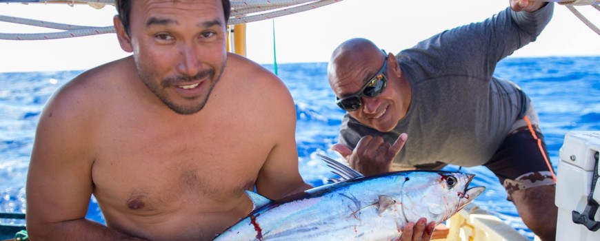
And then yesterday – it happened. The strike came in the afternoon on our starboard lines. Immediately the fishing team sprung into action and landed the fish with expert precision. The 12-pound aku never even had a chance. Within minutes of getting the fish on board, Captain Archie had it broken down as he has done literally thousands of times. Precise, accurate, without hesitation. Each slab of fish was neatly tucked into different piles depending on the dish that it was destined for. Russell and Rex took the second shift of cutting up the fish slabs as Archie took off to the galley whipping the head and other parts into a pot to start the hours-long process of making miso-lime-fish head soup.

While Archie boiled down the head for the soup, he also fried the aku bone to the predetermined papaʻa status. As that was finishing, Russell and Rex brought a pan-full of sashimi on a bed of cabbage. Russell took the last few slabs and quickly turned them into sesame-crusted seared aku. A huge pot of rice was waiting in anticipation of the fish dishes, as were three different sauces hand-made to complement the meal.

The meal tasted as good as it looked (and hopefully as it sounds), but nine long days of humbling strikes with no fish landed made this one taste even better. The usual mealtime banter was mute with appreciation for all the great food and hard work by our resident fishermen. And what was produced out of this single fish and a few simple ingredients from the canoe’s galley were a true testament to the perspective of good practice making perfect. Special thanks to Captain Archie, Russell and Rex for making it all look so easy.

We’ll be standing by 72, lines out, waiting…
Nāʻālehu


Homecoming__-_Save_the_Date_-_Banner

Hōkūle‘a Homecoming – Save the Date

Sign up for updates and be the first to know as we continue to detail homecoming festivities during the week of Hōkūleʻa’s homecoming
on June 17, 2017!

Hōkūleʻa Update | February 18, 2017

Navigation Update
Voyage Day: 9

Speed and location
Canoe average speed: 6 kts
12 hour estimated total: 68 nm South, -1 nm East
Leg estimated total: 1017 nm South, 302 nm East

Latitude 18.5 South

Heading: Nā Leo Kona

Wind: Noio Malanai 15-20 kts

Swell direction and height: Noio Malanai 3-4 ft

Cloud type and %cover: Cumulus, 30%

Temp: 70’s, plus windchill

Rig: #9 jib, Main and Mizzen 36 triangle

Wildlife: Caught an AKU – Great dinner! Caught malolo too.


Aloha nui kākou,

We’re 9 days and more than 900 miles into this leg of the journey (we think we eclipsed the halfway mark of this leg within the last 24 hours), and the crew is really getting into the groove of being at sea. The schedule is different than what we have back home, but there are some parallels. We had to “clean house” yesterday, scrubbing down the whole canoe to make sure that she is clean and tidy; and there are always the inescapable chores like washing clothes and washing dishes. But past that, the experience of being out here and being at home are two pretty distinct realities. As we sail along and the days give us time to ponder, I can safely say that we all take time in our minds to compare the two experiences, going down the road of thinking about everything that we miss back at home and the things we find we can do without. I took an informal poll yesterday and asked the crew what they missed or didn’t miss back at home.

Almost everyone said “family” as either the first or second thing that they miss while they are out here. Many of us have kids; some have small children, while at least one has grand kids. They talked about this leg being long enough where they are certain to miss a section of the kids growing up, that they will come back and they know the kids will have changed since they left.

A couple of the veteran crew members commented on how they used to feel so much more separated from family when they voyaged, and how much better the communications are now than before. The satellite phone revolution has made it pretty easy to get in touch with family as we sail along. The days of single sideband and phone patches are long gone. On the topic of communications, one long time crew member said first and foremost they did not miss their cell phone and they were happy to be without communications for the month, but just a few minutes ago that very same individual came by to the communications box to ask to connect with his wife. Some habits do die hard I guess.

There were a couple of the regular responses about missing ice cream or hot showers or other comforts that we can find at home on any given day, but no one really was too quick to miss the easy stuff. It seems that we are happy to trade some of those comforts of home to be here, in the middle of the ocean, more than a thousand miles out of the last port. That’s not to say that voyaging and leaving the comforts of home is for everyone – the people who come out here mostly know what they have to give up to get here and will do so happily. After 40 years PVS is pretty good about making sure that people sign on to a voyage eyes wide open, as prepared as they can be about what to expect before getting on board for a month.

The things that people didn’t miss might be a little more predictable for most. Constant contact, traffic, work and always being on-the-go were common themes across almost all the crew answers. It seems that everyone is more than happy to trade the pace of regular life to that of 5-6 kts at a time. Getting anywhere at 5 mph at home would drive most of us crazy, but out here it’s welcomed. I must admit, when a couple people commented that they didn’t miss email, I felt left out as I have to check the canoe email multiple times a day.

When I think about what responses were and weren’t, I realize that no one said they miss the news, or the latest episode of Game of Thrones, or US politics, or the game scores of whatever sport is in season now. It seems that some of dazzle or distraction that we have in front of us at home isn’t really that important once you are faced with the option of living at a different pace and in a different space.

And of course, I saved the best response for last. When asked “what do you miss about home?”, two people replied “I am home.” As it turns out, for some, Hōkūleʻa has everything we need…

We’ll be standing by 72,

Aloha to you all,
Nāʻālehu and the Leg 28 Crew


Homecoming__-_Save_the_Date_-_Banner

Hōkūle‘a Homecoming – Save the Date

Sign up for updates and be the first to know as we continue to detail homecoming festivities during the week of Hōkūleʻa’s homecoming
on June 17, 2017!

Hōkūleʻa Update | February 17, 2017

Aloha all,

We’re whipping along here, in great Hōkūleʻa fashion. We’ve been at 6-6.5 kts steady all day, changing sails about 7-8 times throughout the day searching for the right sail set to match the speed and direction that we needed. Our navigators are on a 24-hour watch, doing a great job and working well together.

Below is the technical update that they generated about the last 12 hours.

SB 72,
Nāʻālehu


Voyage Day: 8

Speed and Location:
Average speed 6.5 kts (Max = 7+ kts, Low = 4 kts)
Last 12 hours: 72.5 nm along Nalani Kona, 60 nm South and 0 nm East or West

Heading: Nalani Naleo Kona

Wind: 10-15 kts, gusting 18-20 Noio, Manu Malanai

Swell direction and height: 8 foot Manu Malanai, 6 foot ʻĀina Malanai, and building

Cloud type and %cover: Mostly clear, small trade wind clouds.

Temp: Upper 70’s

Rig: Many, and wide range of sail changes throughout the day, at least 7 different sail configurations. At sunset, we are running Main and Mizzen 36 triangle, and a #7 jib

Wildlife: Marlin and some other large fish got on the line but worked their way off (to our fishermen’s disappointment). Spotted few birds today as well.


Homecoming__-_Save_the_Date_-_Banner

Hōkūle‘a Homecoming – Save the Date

Sign up for updates and be the first to know as we continue to detail homecoming festivities during the week of Hōkūleʻa’s homecoming
on June 17, 2017!

Hōkūleʻa Update | Navigation Basics

Blog by Nāʻālehu Anthony, Jason Patterson and Haunani Kane

As we make our way down south, our navigation team is using this time on board to “dial in” their navigation techniques. This includes the way we explain the concepts and skills we have learned and continue to learn; through teaching, one sharpens the learning. While everything that we discuss below can be found on the website, on this leg of the journey we are writing in great detail and sending back regular navigation iPad updates so that those who are interested can get a deeper look into the art and science of non-instrument navigation.

Navigation at its simplest is about observation of your environment, and making sense of that environment to give you clues about where you are and where you are going. More than a thousand years ago, canoes like this one were used to settle almost every inhabitable landmass all through the Pacific, an area covering more than 10 million square miles. Simply put, water was seen as a way of connecting islands rather than separating them. This was done in a time before metal was used in this region, and before the magnetic compass was used as well. But what these early voyagers cultivated and utilized was a very powerful sense of observation; that, coupled with an oral tradition that allowed those observations to compound generation upon generation, made for a robust information set over time. The system of wayfinding that the navigation team is using today been in consistent practice, unbroken over the generations, in some of the more remote corners of the Pacific like Micronesia. Pwo navigator Pius Mau Piailug from the island of Satawal in Micronesia brought this system to Hawaiʻi in the 1970’s, where it was modified into what is taught by Pwo Navigator Nainoa Thompson to students like those who make up the navigation team on this current leg.

It gets very complicated in practice, but at its essence, the navigation system answers two basic questions: 1) How fast are you going?, and 2) In what direction are you going?

How fast are we going? Seems like a simple enough question – that equation we were taught in our math classes in school, D=RxT or Distance = Rate x Time. We start first with time, which is pretty simple using natural cues. For our purposes, we estimate on this leg that sunrise is 6am and sunset is 6pm, or 12 hours apart. Our navigators track distance covered every 12 hours, calculating their estimates of total mileage traveled in 12 hours between sunrise and sunset, and sunset and sunrise. They do break down the day into smaller units of time, which they will get into over the next few days as they discuss the navigation strategies they use.

Rate or speed is a little more esoteric. A while back, someone figured out that if you count the number seconds it takes for something to travel between the first ‘iako (crossbeam) on the canoe and the last, and divide 25 by that number of seconds, you get speed of the canoe in knots (kts) or nautical miles per hour.

For example, if you throw a watermelon rind or orange peel into the water at the first ‘iako and you count 5 seconds to reach the back ‘iako, the canoe is travelling at 25/5 = 5 kts. If your count takes less time for that peel to get to the last cross beam, then naturally you would estimate that the canoe is going faster. Here’s the rough table we use to calculate speed, using the seconds it takes for an object to pass from front to back ʻiako:

3 seconds is about 8 kts
4 seconds is about 6 kts
5 seconds is about 5 kts
6 seconds is about 4 kts
8 seconds is about 3 kts

This speed check is done constantly so that different speeds (and thus, distance traveled) can be calculated across different hours as the day or night wears on. Every 12 hours we estimate the distance, and combined with the previous distance estimations, that gets us a total distance travelled over the course of however many days we have traveled. If we travel at 5 kts for the entire period from sunset to sunrise, we calculate 5 kts x 12 hours = 60 miles. In general, we find that Hōkūleʻa averages about 120 miles a day, or about 5 kts.

For the next question – In what direction did we go when we travelled all those miles? – we use the Hawaiian star compass that has become a familiar image to so many.

The fundamental design of this compass is thousands of years old. Nainoa learned the compass from Mau, and from that the Hawaiian star compass evolved during Nainoa’s training for the 1980 voyage to Tahiti. It is a 32-point compass in which stars, wind and waves are used to determine direction. The four cardinal points; ʻĀkau (North), Hema (South), Hikina (East) and Komohana (West) anchor the corners of the compass. Each of the seven sections or houses are named the following: Lā, ‘Āina, Noio, Manu, Nālani, Nā Leo and Haka. If you look at the graphic, these houses radiate out from east and west and fan towards north and south as mirrors of each other in the four quadrants. To distinguish amongst repetitive houses, each quadrant is named as well; Koʻolau, Kona, Malanai and Hoʻolua, for the general main winds that we see in Hawaiʻi.

On Hōkūleʻa, we imagine the canoe is in the center of the compass, and the star compass itself is overlaid on the canoe by marking the 32 houses along the railings, radiating from the navigator’s perch in the back corner of the canoe. The canoe is depicted in the star compass graphic by the ʻIwa bird. To reference the direction that the canoe is heading, the navigator will stand in the back corner of the canoe where the beam is lashed to the rails and identify which houses the stars, moon, sun, swells, etc. are rising or setting in. For example, on this sail down to Rapa Nui, we have the constellation Orion setting in the west off of our starboard beam (e.g. the right side of the canoe). The star Mintaka, which is the bottom star in Orion’s belt when it’s setting, sets due west; given this known point, we can then orient the canoe to the star and use the markings along the rail to set a southerly course towards Rapa Nui.

So far it’s been about a week out at sea, and we’ve experienced nearly complete cloud coverage each night, as well as a big moon that masks the light of the stars. Bright stars like those in Orion, Aʻa (Sirius), the Southern Cross, and the planets have been a blessing when they are visible, but their appearance is often short-lived, challenging the navigators to quickly identify the celestial bodies and recalibrate their direction.

We’ll continue to blog about the navigation fundamentals, challenges, and learning opportunities as we continue on our course line towards Rapa Nui. Please check out our live tracking map; these navigation deep-dives should bring what you see to life. Stay tuned for more updates and information from the crew of Leg 28 of the Worldwide Voyage.

We’ll be Standing By 72,
Haunani, Jason and Nāʻālehu


Homecoming__-_Save_the_Date_-_Banner

Hōkūle‘a Homecoming – Save the Date

Sign up for updates and be the first to know as we continue to detail homecoming festivities during the week of Hōkūleʻa’s homecoming
on June 17, 2017!
Hōkūleʻa Update | February 14, 2017

Naalehu Anthony

Blog by Nāʻālehu Anthony

Aloha nui kakou,

Navigation Report, Day 5:

Canoe Speed: average 5 kts
12 hour estimated total: 55 miles South and 8 miles East
Leg estimated total: 500 miles South and 296 miles East

Heading:
22 miles Nalani Kona and 29 miles Naleo Kona

Wind: 10-15 kts, Manu

Swell direction and height:
Manu Malanai 4-5 kts

Cloud type and %cover: 80%

Temp: 80 degrees F

Rig: 36 main triangle, 41 mizzen triangle, currently jib 17C

Wildlife: Dolphins, malolo and birds

The Balance

This canoe has a totally different rhythm when she sails in balance, trimmed to the point where steering isn’t needed. We come up on watch in the dead of night, and everything is virtually silent. The wind makes a little noise as the sails spill power in unison, and we feel the lift that we have been searching for in the days past. The normal surging sound of the water fluttering across the steering blade is replaced by a simple strumming of the water on the hulls as she slips seamlessly through the sea. We are sailing the razor’s edge, balancing our three sails against the waterline of the canoe. To do this we use the 15 5-gallon jugs for a total of 600 or so pounds, plus the weight of the crew. Even the simple act of walking forward on the deck to check the bow will change the waterline, and the canoe will shift course a bit. And so we get calm and settle in for a long night of watch – another balancing act, trying to stay alert without any of the physical activities of steering or moving around.

The clouds are back, masking the millions of points of light that are used to help us find our way. Mahina the moon seems to fight against them as she strains to be known in the night sky. The conditions have been similar throughout the night. The wind constant, the sea state consistent, and so that means that our line is straight. With no one steering, our course is a true line south of west.

In the almost dark night, we strike up a conversation about regular life back at home. What is it like where we are going? How did we find our way to this canoe? The relationships feel ancient, stretching beyond even the decades some of us have known each other and this canoe. While the language we use might be different, I’m willing to bet that the conversations have been similar for a millennia.
The dark quiet night allows us to imagine: The vessel is very similar. The technology to find our way is the same. As are the heavens we hope to see and the ocean that we slide through. Suddenly, the point of all of this dawns on me – no matter the struggle or the colonizer or the adversity or passage of time, this part of us refused to slip away into the darkness of myth and legend. The canoe story found its way back to us, and we to it; it is the moʻolelo that binds us all and guides us forward.

Me ka haʻahaʻa,

SB 72,
Nāʻālehu


Homecoming__-_Save_the_Date_-_Banner

Hōkūle‘a Homecoming – Save the Date

Sign up for updates and be the first to know as we continue to detail homecoming festivities during the week of Hōkūleʻa’s homecoming
on June 17, 2017!

Hōkūleʻa Update | February 13, 2017

Naalehu Anthony

Blog by Nāʻālehu Anthony

Aloha nui kakou,

Sunset Navigation Report, Day 4:

Canoe Speed: 5 Kts
12 hour estimated total: 54 nautical miles S, 36 nautical miles E
Leg estimated total: 306 miles E of Nalani Kona, 383 miles S
Latitude: approximately 8° S

Heading
Average: Hema
Range: Initially we headed Haka Kona after sunrise. A line had to be removed from Gershon’s prop, so both vessels stopped and drifted west for approximately an hour.

Wind
Speed: 5 kts
Direction: After 12 pm, wind was out of Manu Malanai

Swell direction and height: Ocean state is a lot more distorted than we’ve seen previously. Secondary wave out of Manu Malanai appeared and was aligned with the wind. Southerly wave still prevalent but the southeast wave is becoming dominant.

Cloud type and % cover: 100% cloud cover for the early morning, 75% for the second half. Cumulus in the low level and cirrus clouds in the upper level. Passed through multiple squalls with rain throughout the day.

Temp: mid-70s F
Rig: 17C Jib, 36 triangle main, 41-triangle mizzen.
Birds: Some ʻiwa, koʻaʻe kea.

Latitude fix: None during the day. We will check latitude tonight.

Dinner: Chicken curry with mango chutney, and chocolate chip cookies for dessert.


Homecoming__-_Save_the_Date_-_Banner

Hōkūle‘a Homecoming – Save the Date

Sign up for updates and be the first to know as we continue to detail homecoming festivities during the week of Hōkūleʻa’s homecoming
on June 17, 2017!